
…
- On foot
Helsingfors to Estancia Cristina
4 days · a crossing between two historic estancias
- duration
- 4 days
- distance
- ≈ 44 km
- highest point
- 1,019 m
- difficulty
- Expedition
Trail conditions: Good ·
Confirmed departure
- 3 Mar to 6 Mar · closed group · 2 travellers
That group is closed. To join us, ask for another date: we put your group together.
Group departure · the final price depends on the group and the nights at the estancia
The numbers
Measured on our own track, with heights from the Copernicus GLO-30 model.
- Walking
- 44.3km
- Total ascent
- +2,738m
- Total descent
- −2,829m
- Lowest point
- 180 m
- Highest point
- 1,016 m
- duration
- 4 days
- Difficulty
- Expedition
The trek
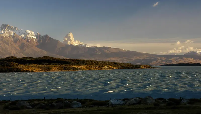
Four days far from roads and huts, from the shore of Lago Viedma to Estancia Cristina.
We walk through valleys, glacial moraines and rivers, much of it without a marked trail. Each camp is chosen for the terrain, the weather and the group, so no crossing is quite like the last.

On the last day we walk down the valley to Estancia Cristina. Arriving on foot after days of camping gives the place a different meaning.
Day by day
Day 1
Helsingfors → Seno Moyano
10 km6–7 h+900 m⌂ Seno Moyano
We leave Hostería Helsingfors on the shore of Lago Viedma. After checking the gear we walk towards Seno Moyano through native vegetation and open slopes. We camp wherever the wind is kindest, with the lake below.
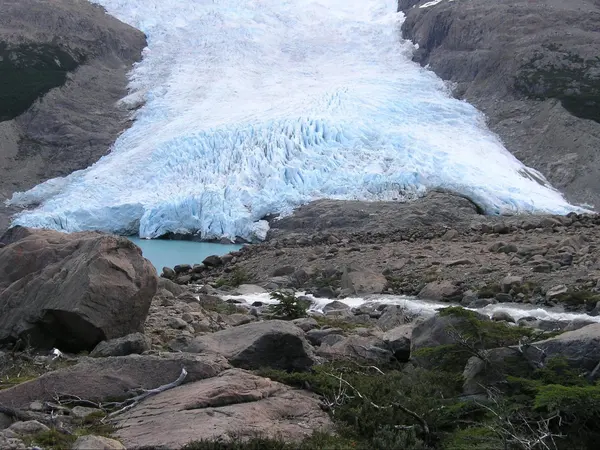
The glacier reaching the lake Day 2
Seno Moyano → Cerro Norte moraine
15 km7–8 h⌂ Cerro Norte moraine
The hardest day. With no marked trail we cross two mountain passes and Cerro Norte starts to fill the view. The ground gets more alpine and exposed. It is not climbing, but you have to read the mountain. We camp in the shelter of the moraine.
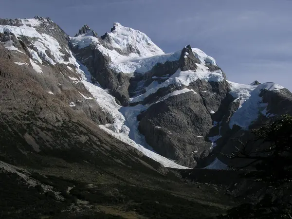
The valley and the snowy peaks Day 3
Cerro Norte moraine → Río Norte canyon
9 km+600 m⌂ Río Norte
We cross a smaller pass and drop into the Río Norte canyon, with views of lakes Anita and Pearson. Rock, open ground and glacial features. We camp near the river.
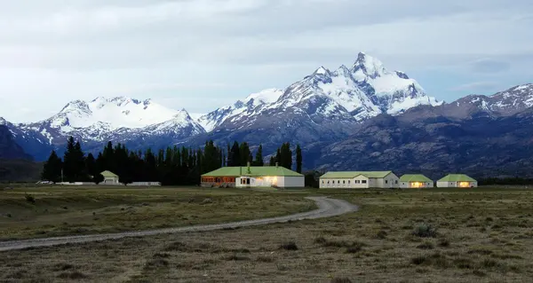
Arriving at Estancia Cristina Day 4
Río Norte → Estancia Cristina
6 km4–5 h−400 m⌂ Estancia Cristina
The last day is shorter. We walk down the valley as the landscape softens, until Estancia Cristina appears. Arriving on foot after days of camping gives the place a different meaning.
What is included
- Professional mountain guide, in Spanish or English
- All meals on the trek: breakfast, packed lunch and dinner
- Shared expedition tents
- Group camping and cooking gear
- Satellite communication and radio
Extra, if you need it
- Accommodation before the trek
- Accommodation at Estancia Cristina (unless stated)
- Personal trekking gear
Worth knowing
- The itinerary may change with the weather or trail conditions.
- A good level of fitness is recommended.
- Small groups.
- Tell us beforehand about dietary needs, allergies or medical conditions.
- We send the packing list once your booking is confirmed.
- Private departures are available.
- For safety, the guide may change the route if the mountain asks for it.
Crossing guide
Helsingfors to Estancia Cristina trek: the complete guide
Everything worth knowing before you cross on foot from Lago Viedma to Lago Argentino: the terrain, the passes, the camps, what to pack and how you get back.
The crossing at a glance
| Length | 4 days and 3 nights of camping |
|---|---|
| Distance | About 44 km, measured on our own track |
| High point | 1,019 m, on the passes by Cerro Norte |
| Longest day | Day two: about 15 km, 7 to 8 h, two passes with no trail |
| Starts at | Hostería Helsingfors, on the shore of Lago Viedma |
| Ends at | Estancia Cristina, on the north arm of Lago Argentino |
| Trail | No marked trail for much of it, and no huts |
| Level | Mountain crossing: good fitness and backpacking experience |
Distance and height measured on the GPS track of our own trips, with the Copernicus terrain model.
From one lake to the other, between two estancias
The crossing links two historic estancias of southern Patagonia. Helsingfors looks out over Lago Viedma from its southern shore; Estancia Cristina lies on the other side of the mountains, on the north arm of Lago Argentino, near Upsala Glacier. Between them there is no road and no park trail: only valleys, moraines and passes you can cross on foot.
Alberto Del Castillo, who founded Fitz Roy Expediciones in 1995 and arrived in El Chaltén in 1985, chairs Estancia Cristina. The people at Helsingfors have been his friends for years. Both estancias authorise the crossing, which is why we walk it the way you walk from one familiar house to another. Read more →

Walking without a trail
On the Park trails, the way is already decided. Not here. Much of the route is walked by reading the ground: where the moraine is firmer, where the stream can be crossed without getting wet to the knee, which slope blocks the wind when it is time to pitch the tent. That craft is the guide’s, and it is what makes the crossing safe and, at the same time, never quite the same twice.
- Glacial moraines
- Loose rock left behind by the retreating ice. You walk slowly, with poles.
- Two mountain passes
- On day two, by Cerro Norte, over open, exposed alpine ground. It is not climbing: it is walking with care.
- The Río Norte canyon
- On day three you drop into a rock canyon, with lakes Anita and Pearson below.
- Valleys and rivers
- Stretches of grassland and meltwater streams, where the guide picks the crossing.

Who is this crossing for?
For people who have already walked several days with a pack and want something other than the El Chaltén trails: fewer people, more silence, more unmarked mountain. You do not need to climb or navigate: the guide does that. You do need to be fit for 6 to 8 hour days on rough ground, four days in a row, with your pack on.
What to pack
We send the full list when you book. The essentials:
- Broken-in hiking boots with ankle support
- Waterproof. You will be on loose moraine, wet bog and slick rock for days.
- Waterproof jacket and trousers
- Truly waterproof, not windproof. The westerly brings sideways rain in minutes.
- Warm layers
- A synthetic or wool base layer, a fleece or down jacket, hat and gloves. It is cold on the pass even in January.
- Sleeping bag and mat
- Warm enough for nights near freezing. If you do not have one, ask us before you travel.
- 50 to 65 litre backpack
- With a hip belt. It carries your personal gear and a share of the group food.
- Trekking poles
- A real help on long descents and stream crossings.
Before and after
The crossing starts at Helsingfors and ends at Estancia Cristina, which has no road: you leave by boat across Lago Argentino. We arrange the transport in and out, and where you sleep before the start, once the date is confirmed. To compare with the other way of walking to Cristina, the crossing from the Guanaco valley goes over Paso Sombrero and takes five days. Read more →
- On foot
44.3 km · height 180 a 1,019 m
Route measured on our own track. Touch the profile to see the height at each point.
Wind on the way
It is the first thing we check in the morning. Town can be calm while the lake is blowing hard, so we show both heights.
Loading the forecast…
Helsingfors to Estancia Cristina: questions
What is the Helsingfors to Estancia Cristina crossing like?
Four days with no marked trail or huts, from the shore of Lago Viedma to Estancia Cristina, crossing mountain passes with views of lakes Anita and Pearson.
What is included?
Guide, all meals on the crossing, shared tents, camping and cooking gear, and satellite communication and radio.
Where does the trek start?
At Hostería Helsingfors, on the shore of Lago Viedma. It ends four days later at Estancia Cristina.
How far is it?
About 44 km over four days, measured on our track. The longest day is the second, about 15 km.
How hard is it?
It is a mountain crossing. On day two, the hardest, there is no marked trail: you cross two mountain passes over alpine, exposed ground. It is not climbing, but you need to be fit and comfortable walking several days with a pack.
Where do you sleep?
In tents: Seno Moyano, the Cerro Norte moraine and the Río Norte canyon. On day four you reach Estancia Cristina.
How do you get back from Estancia Cristina?
Estancia Cristina has no road: you leave by boat across Lago Argentino. We arrange the return once the date is confirmed.
How much is the Helsingfors to Estancia Cristina trek?
From USD 4,500 per person, on a group departure of several people, with guide, meals and camping gear. The final price depends on the group size and how many nights you spend at Estancia Cristina or Helsingfors. Message us and we send it for your date.
Who guides the crossing?
A local guide from El Chaltén. It crosses estancia land and long stretches with no trail and no signal. We run it with the authorisation of Helsingfors and Estancia Cristina, with a mountain guide and satellite communication.
Is there phone signal?
No. The guide carries satellite communication and a radio for the whole crossing.
What happens in bad weather?
The itinerary follows the weather and the state of the ground. For safety, the guide may change a stretch if the mountain asks for it.
Can I join on my own?
Yes. Message us and we will tell you the next dates. Private departures are also available.
Can I add nights at Estancia Cristina or Helsingfors?
Yes. Together with the group size, it is what changes the final price most: we put it together with the nights you want.
Can you arrange accommodation and transfers?
Yes, if you like: accommodation before and after the trek and transfers from El Calafate or El Chaltén.
How is it different from the Guanaco to Estancia Cristina trek?
Helsingfors to Cristina is 4 days from Lago Viedma, with no trail and two passes by Cerro Norte. Guanaco to Cristina is 5 days over Paso Sombrero, with the Southern Ice Field in view, ending at Upsala Glacier.
How high does Helsingfors to Estancia Cristina go?
The highest point of the route is at about 1,019 m above sea level. El Chaltén sits at about 400 m.
Estancia Cristina: history and how to get there · The best hikes in El Chaltén · 2 to 5-day itineraries · Packages with hotel and transfer · When to visit El Chaltén · The National Park and its fee · How to get to El Chaltén · Short hikes · Day trip from El Calafate
El Chaltén packages
Live
The mountain logbook
What people who walked with us write. Every Google or Tripadvisor review links to the original.
5.0
8 reviews · Google · Tripadvisor
The logbook opens this season: the first entry could be yours.
Photos
What happens when you book
The full policy →- 01Written confirmationYour place is confirmed once we receive payment and send you the confirmation.
- 02Meeting point and timeThey come with the confirmation. Depending on the trek, we meet in town or pick you up.
- 03What to bringWe send you the list: hiking boots with good grip, warm layers, a waterproof jacket, water and food.
- 04If the weather says noWe still go in rain or wind, within the Park’s safety rules. Only a very heavy snowfall near winter moves the trek to the next day.
- 05If you need to cancel30 days or more before: full refund; 15 to 29 days: 50%; under 15 days: no refund.
Other treks
- Laguna de los Tres19.6 km →
- Laguna Torre16.6 km →
- Laguna de los Tres Sunrise Trek19.6 km →
- Loma del Pliegue Tumbado16.6 km →
- Loma de las Pizarras21.9 km →
- Cerro Madsen23.1 km →
- Paso del Cuadrado21.5 km →
- Guanaco to Estancia Cristina5 days →
- Huemul Circuit4 days →
- Laguna Toro2 days →
- Two Glaciers: Vespignani Glacier4 km →
- Cerro Torre to Fitz Roy24.9 km →
- Mirador de las Águilas6.2 km →
- Laguna Torre and Mirador Maestri20.4 km →
- Eléctrico Valley and Piedra del Fraile14.2 km →
- Laguna Pollone22.1 km →
- Piedras Blancas Glacier9.9 km →