
…
- On foot
Loma del Pliegue Tumbado
The fullest view of the massif, out and back from town
- distance
- 16.6 km
- elevation gain
- +1,040 m
- highest point
- 1,500 m
- duration
- 8 to 9 h
- difficulty
- Demanding
Trail conditions: Take care ·
BookUSD 225The trail and the map Coming as a group? Ask for our group rateStretch by stretch
The trail cut into stretches, measured on the track. Tap one to see it on the map and the profile.
- On foot
8.1 km · height 452 a 1,507 m
Approximate route: OpenStreetMap trails to the top. Touch the profile to see the height at each point.
The numbers
Measured on the OpenStreetMap route (approximate), with heights from the Copernicus GLO-30 model.
- Walking
- 16.6km
- Total ascent
- +1,040m
- Total descent
- −1,040m
- Lowest point
- 461 m
- Highest point
- 1,500 m
- Steepest stretch
- 25 %average grade over 1 km
- Steeper than 15 %
- 5.3 km
- Walking time
- 8 to 9 h
- Difficulty
- Demanding
The trek
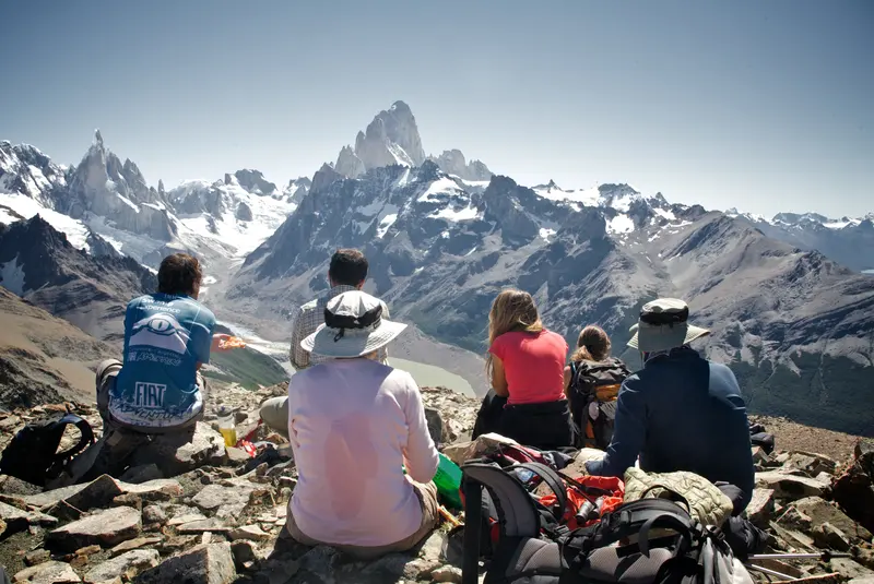
One of the finest panoramic hikes in El Chaltén: a steady climb above the forest to a viewpoint facing Fitz Roy, Cerro Torre, Laguna Torre and the Río de las Vueltas valley.
Unlike the valley trails, this one gains height steadily and the massif opens up with every bend.

The last stretch crosses open alpine ground: exposed, wild and very Patagonian. In strong wind the guide decides how far we go.
We return to town on the same trail.
How the day goes
- Walk out of town
- Climb through the lenga forest
- Open alpine ground
- Pliegue Tumbado viewpoint
- Back the same way
Trail guide
Loma del Pliegue Tumbado hike from El Chaltén: the complete trail guide
The viewpoint that looks at Fitz Roy and Cerro Torre head-on, both at once. Fewer people than the classics and a lot more climbing.
Loma del Pliegue Tumbado is a ridge about 1,500 m high, southwest of town. From the top you see the whole massif head-on: Fitz Roy, Cerro Torre, Laguna Torre below and the Río de las Vueltas valley. There is no lake at the end and no glacier beside you: the reward is the view. It is a long day, almost all uphill, and the last stretch is open ground where the wind hits hard.
The numbers
| Route | Distance | Time | Climb |
|---|---|---|---|
| From town, one way | 10 km | about 4 h | 1,000 m |
| There and back, OpenStreetMap route | 16.6 km | 8 to 9 h | 1,040 m |
One way: official Park figures. There and back: measured on the OpenStreetMap route, approximate.
Where it starts
At the Ceferino Fonzo Visitor Centre of the Park, at the entrance to town. Right there the path splits in two: left to the Los Cóndores and Las Águilas viewpoints, right to Loma del Pliegue Tumbado and Laguna Toro. The first kilometres are shared with the way to Laguna Toro, which carries on toward the Ice Field; the junction is signposted. Before you set off, ask at the Visitor Centre how the trail is.

Stop by stop
- Visitor Centre
- The start. You take the right-hand path, toward Laguna Toro and Pliegue Tumbado.
- Pampa de las Carretas
- After about an hour, an open plain. To the south you see Cerro Huemul and Lago Viedma; behind you, Cerro Torre and Fitz Roy.
- Lenga forest
- The trail climbs through the forest up to about 1,000 m. It is the only shade of the day.
- The fossils
- Above the forest there is scrub and rock. Among the stones are marine fossils about 100 million years old: look, take photos and leave them where they are.
- The yellow stakes
- The path gets faint. Yellow stakes mark the way to the viewpoint, at about 1,500 m.
- The summit
- From the viewpoint, one more hour and about 280 m of steep climbing lead to the summit, with a 360° view. With snow or strong wind, the day ends at the viewpoint.
What the trail is like
It first climbs through steppe and lenga forest, with Fitz Roy slowly appearing behind you. Then the forest ends and the alpine ground begins: rock, short grass and a lot of sky. That last part is the most exposed. In strong wind you walk leaning into it and it is cold even in sunshine; on a very windy day it is better to stop lower down and enjoy the view from there.

What you see from the top
It is one of the few viewpoints where Fitz Roy and Cerro Torre fit in the same photo, with Laguna Torre below. The other way, the Río de las Vueltas valley and the town. On the way back down, El Chaltén appears whole from above.

Before you go
- When
- November to April. Pick a day with little wind: up there it is far stronger than in town. It can snow up high even in summer, and in spring and autumn the last stretch often has snow or mud.
- Water and food
- Bring plenty of water and food for the whole day: it is nearly all uphill.
- Toilets
- There are no toilets on this trail.
- Warm layers
- Windproof jacket, hat and gloves, even if it is warm in town.
- Fee
- It is inside the National Park: the entrance fee applies.
| 1 day | 3 days | 7 days | |
|---|---|---|---|
| Foreign visitors | $ 50,000 | $ 100,000 | $ 175,500 |
| Argentine nationals | $ 25,000 | $ 50,000 | $ 87,500 |
| Santa Cruz residents | $ 8,000 | $ 16,000 | $ 28,000 |
| Students (Argentine ID) | $ 15,000 | · | · |
Argentine pesos per person, since 1/6/2026. Paid by QR or card; no cash at the booths.
With a guide or on your own
You can do it on your own if you have experience: the lower part is well marked. Up high the path is easy to lose, especially in snow or cloud, and there is no shelter. If you go alone, start early, carry a headlamp and check the sunset time.
We walk it with groups of up to 8, straight out of town. The guide watches the wind all day and decides how high to go: on this hike that call matters most.
Wind on the way
It is the first thing we check in the morning. Town can be calm while the lake is blowing hard, so we show both heights.
Loading the forecast…
Loma del Pliegue Tumbado: questions
How long is Loma del Pliegue Tumbado?
8 to 9 hours: 16.6 km out and back and about 1040 m of climbing.
What do you see from Pliegue Tumbado?
The whole massif head-on: Fitz Roy, Cerro Torre, Laguna Torre and the Río de las Vueltas valley.
Is it exposed to wind?
Yes, the last stretch crosses open alpine ground. In strong wind the guide decides how far we go.
Where does the trail start?
At the Ceferino Fonzo Visitor Centre, at the entrance to El Chaltén. We walk straight out of town, no transfer.
What does Pliegue Tumbado mean?
It is a geology term: a "pliegue tumbado" is a recumbent fold, a layer of rock bent over until it lies on its side. The ridge is named after a fold like that in its rock. Above the forest there are marine fossils too.
What does the guided hike include?
A professional mountain guide, in Spanish or English, and a VHF radio. We walk out of town. The packed lunch is optional.
When is the best time?
November to April, on a day with little wind. It can snow up high even in summer; with snow on the last stretch, the day ends at the viewpoint.
Is there a park fee?
Yes: it is inside Los Glaciares National Park. Since 1/6/2026 a day costs ARS 50,000 for foreign visitors and ARS 25,000 for Argentines, by QR or card (no cash). It is not included in the trek.
The best hikes in El Chaltén · 2 to 5-day itineraries · When to visit El Chaltén · The National Park and its fee · How to get to El Chaltén · Short hikes
Live
The mountain logbook
What people who walked with us write. Every Google or Tripadvisor review links to the original.
5,0
· Google · Tripadvisor
The logbook opens this season: the first entry could be yours.
Photos
What happens when you book
The full policy →- 01Written confirmationYour place is confirmed once we receive payment and send you the confirmation.
- 02Meeting point and timeThey come with the confirmation. Depending on the trek, we meet in town or pick you up.
- 03What to bringWe send you the list: hiking boots with good grip, warm layers, a waterproof jacket, water and food.
- 04If the weather says noThe guide decides. If we cannot go, we move you to the next date or give you credit for another trek.
- 05If you need to cancel30 days or more before: full refund; 15 to 29 days: 50%; under 15 days: no refund.
Other treks
- Laguna de los Tres19.6 km →
- Laguna Torre16.6 km →
- Laguna de los Tres Sunrise Trek19.6 km →
- Loma de las Pizarras21.9 km →
- Cerro Madsen23.1 km →
- Paso del Cuadrado21.5 km →
- Helsingfors to Estancia Cristina4 days →
- Guanaco to Estancia Cristina5 days →
- Huemul Circuit4 days →
- Laguna Toro2 days →
- Lago del Desierto and Huemul Glacier3.4 km →
- Cerro Torre to Fitz Roy24.9 km →
- Mirador de las Águilas6.2 km →
- Laguna Torre and Mirador Maestri20.4 km →
- Eléctrico Valley and Piedra del Fraile14.2 km →
- Laguna Pollone22.1 km →
- Piedras Blancas Glacier9.9 km →