
…
- On foot
Laguna Toro
2 days with camping · the first step towards the Southern Ice Field
- duration
- 2 days
- distance
- ≈ 32 km
- highest point
- 1,077 m
- difficulty
- Demanding
Trail conditions: Take care ·
Request my placeThe numbers
Measured on our own track, with heights from the Copernicus GLO-30 model.
- Walking
- 31.9km
- Total ascent
- +1,388m
- Total descent
- −1,388m
- Lowest point
- 393 m
- Highest point
- 1,077 m
- duration
- 2 days
- Difficulty
- Demanding
The trek
No, not Laguna Torre: the other one, the lake hardly anyone knows. While the whole of Chaltén queues for the Fitz Roy photo, you head the other way.
We walk out of town on the same trail that climbs to Loma del Pliegue Tumbado. We cross steppe and wet meadows, climb to almost 1,100 metres and drop into the Río Túnel valley, through lenga forest. It is about 16 km, and the trail is not marked all the way.

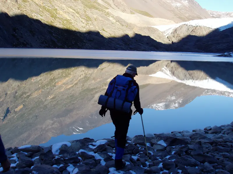
Then you are standing in front of a grey glacial lake, with the Túnel Glacier pouring into it. This is where the Huemul Circuit begins: on the far side of Paso del Viento the ice field starts.
We set up camp by the lake, have dinner and sleep there. Next morning we walk back to town the same way, with Fitz Roy and Cerro Torre ahead.
Day by day
Day 1
El Chaltén → Laguna Toro
16 km+830 m↑ 1,077 m⌂ Laguna Toro
We walk out of town on the Pliegue Tumbado trail, cross the steppe and climb to the high point of the day. Then we drop into the Río Túnel valley, through lenga forest, to the lake with the glacier across it. We set up camp and have dinner there.
Day 2
Laguna Toro → El Chaltén
16 km+570 m
Breakfast facing the glacier, we pack up camp and walk back the same way, now with Fitz Roy and Cerro Torre ahead. We reach town in the afternoon.
What is included
- Bilingual mountain guide
- All meals
- Shared tent
- Radio
Extra, if you need it
- Personal trekking gear
- National Park fee
Worth knowing
- The itinerary may change with the weather or trail conditions.
- A good level of fitness is recommended.
- Small groups.
- Tell us beforehand about dietary needs, allergies or medical conditions.
- We send the packing list once your booking is confirmed.
- Private departures are available.
- For safety, the guide may change or call off the route if the mountain asks for it.
- On foot
31.9 km · height 393 a 1,077 m
Route measured on our own track. Touch the profile to see the height at each point.
Wind on the way
It is the first thing we check in the morning. Town can be calm while the lake is blowing hard, so we show both heights.
Loading the forecast…
Laguna Toro: questions
Is Laguna Toro the same as Laguna Torre?
No. Laguna Torre is the Cerro Torre lake, 8 km from town. Laguna Toro is further south, in the Río Túnel valley, 16 km away: it is the first night of the Huemul Circuit.
How far do you walk?
About 16 km a day, measured on our own track: day one has +830 m of total climbing, with a high point of almost 1,100 m; day two is the walk back the same way. About 5 hours out.
Do I need camping experience?
No. We bring the tents, the stove and the food, and the guide sets up camp with you. You do need to be fit: two long days with a pack.
Do you need to register?
Yes: the Park trekking registration is compulsory and done online. We help you with it before we leave. There are no tyroleans up to Laguna Toro: those come later, on the Huemul Circuit.
Do you pay the Park fee?
Yes: it is inside Los Glaciares National Park. Since 1/6/2026 a day costs ARS 50,000 for foreign visitors and ARS 25,000 for Argentines, by QR or card (no cash). It is not included in the trek.
What is included?
A bilingual guide, the food, a shared tent and the radio. You bring your personal gear; we send the list when you book.
When can you go?
October to April.
Can it be done in a day?
No: we do it in two days, with the night at the lake. It is 32 km there and back.
What if the weather is bad?
We go in almost any weather: wind and rain are part of Patagonia. If the guide sees it cannot be done, we change the date.
The best hikes in El Chaltén · 2 to 5-day itineraries · When to visit El Chaltén · The National Park and its fee · How to get to El Chaltén · Short hikes
Live
The mountain logbook
What people who walked with us write. Every Google or Tripadvisor review links to the original.
5,0
· Google · Tripadvisor
The logbook opens this season: the first entry could be yours.
Photos
What happens when you book
The full policy →- 01Written confirmationYour place is confirmed once we receive payment and send you the confirmation.
- 02Meeting point and timeThey come with the confirmation. Depending on the trek, we meet in town or pick you up.
- 03What to bringWe send you the list: hiking boots with good grip, warm layers, a waterproof jacket, water and food.
- 04If the weather says noThe guide decides. If we cannot go, we move you to the next date or give you credit for another trek.
- 05If you need to cancel30 days or more before: full refund; 15 to 29 days: 50%; under 15 days: no refund.
Other treks
- Laguna de los Tres19.6 km →
- Laguna Torre16.6 km →
- Laguna de los Tres Sunrise Trek19.6 km →
- Loma del Pliegue Tumbado16.6 km →
- Loma de las Pizarras21.9 km →
- Cerro Madsen23.1 km →
- Paso del Cuadrado21.5 km →
- Helsingfors to Estancia Cristina4 days →
- Guanaco to Estancia Cristina5 days →
- Huemul Circuit4 days →
- Lago del Desierto and Huemul Glacier3.4 km →
- Cerro Torre to Fitz Roy24.9 km →
- Mirador de las Águilas6.2 km →
- Laguna Torre and Mirador Maestri20.4 km →
- Eléctrico Valley and Piedra del Fraile14.2 km →
- Piedras Blancas Glacier9.9 km →